| Numero pezzi | |
|---|---|
| Marca | |
| Difficoltà | |
| Artista | |
| Dimensioni puzzle | 116 x 85 cm |
| Formato | |
| Dimensioni scatola | 37 x 28 x 6 cm |
5 motivi per acquistare i nostri puzzle d'arte


55,00€
55,00€
Out of stock
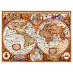
Discover the art style of world map puzzles with Henry Hondius ‘s magnificent 1641 map.
With this edition, Puzzle Arte is pleased to offer you this art puzzle that pays homage to the great artist who, with Mercator, drew an accurate global map: the NOVA TOTIUS TERRARUM ORBIS TABULA.
Questo puzzle è momentaneamente esaurito.
Nel frattempo, ti suggeriamo alcuni puzzle d’arte che potrebbero piacerti!
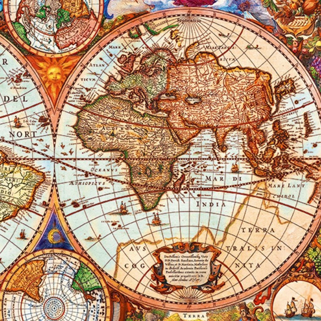
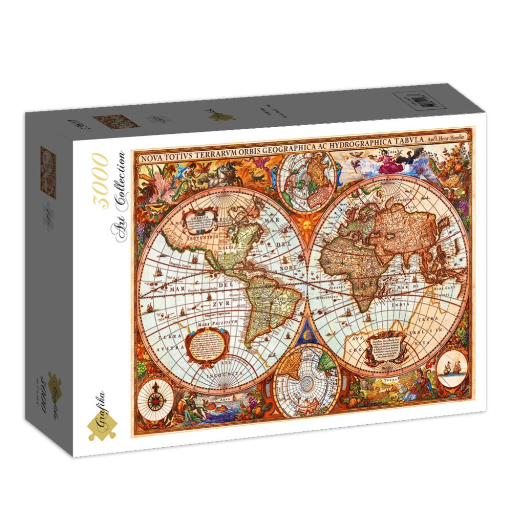
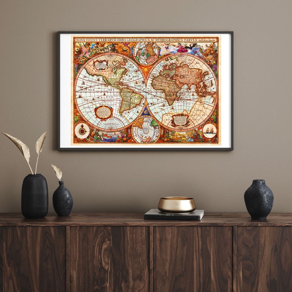
Grafika’s 3000-piece Antique World Map puzzle is a unique work of art celebrating one of the most iconic and detailed world maps of the 17th century: the World Map of Henricus Hondius. This extraordinary representation of the world, first published in the 1630 edition of the Mercator-Hondius Atlas, captures the essence of ancient cartography with lush detail and unique geographical features.
With this magnificent 3,000-piece art puzzle, you can explore the beauty and charm of ancient maps, immersing yourself in a journey through history and art. The date “1630,” visible at the bottom right of the map, marks the original publication of this masterpiece.
This puzzle is ideal for both experienced puzzle enthusiasts looking for a real challenge and those new to the world of large-scale puzzles, thanks to the rich detail that makes assembly easy. The sturdy pieces, precise interlocking, and Grafika quality ensure an engaging and rewarding building experience.
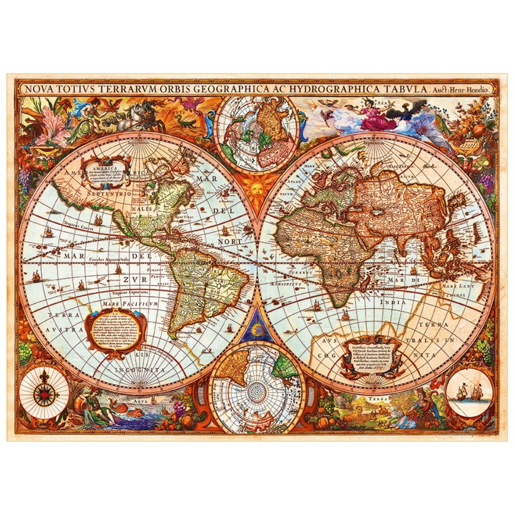
The 3000-piece Antique World Map Puzzle from Grafika is an extraordinary example of an art puzzle and historical map puzzle. This incredible puzzle depicts one of the most famous and detailed world maps ever made: the Nova Totius Terrarum Orbis Geographica ac Hydrographica Tabula, drawn by Henricus Hondius in 1630, one of the icons of 17th-century cartography.
This puzzle is ideal for those who enjoy complex challenges and for history, art, and geography enthusiasts. The extraordinary richness of detail and vibrant colors make it an immersive and fascinating experience, capable of transporting you to a time when discovering the world was still an adventure.
The Grafika puzzle pieces are sturdy, precisely cut and fit together perfectly, while the high-definition printing enhances every detail of the map. Perfect for those seeking a challenging and rewarding puzzle, a true gem for lovers of antique maps and grand compositions.
 | Number of pieces 3000 |  | Brand D-Toys |
 | Puzzle dimensions (cm) 116 x 85 |  | Box dimensions (cm) 40 x 27 x 9 |

Well finished box
Wonderful gift idea
masterpiece of art
Passion for collectors
3000 pieces
Standard grid
Grafika’s 3,000-piece Antique World Map puzzle faithfully reproduces one of the most famous and richly detailed world maps of the 17th century: the “Nova Totius Terrarum Orbis Geographica ac Hydrographica Tabula” by Henricus Hondius . This extraordinary map was first published in the 1630 edition of the Mercator-Hondius Atlas and is still considered an absolute masterpiece of Baroque Dutch cartography.
At the bottom right of the original map, the date 1630 is visible, identifying the first version of the map. Four distinct versions of this map have been identified between 1630 and 1666, a testament to its immense popularity. Thanks to its success, Hondius’s work became the basis for many other cartographers of the time. The copies signed by Hondius remain among the most detailed and precise, true reference points for ancient cartography.
This map is enriched with an incredible amount of detail and whimsical and fascinating illustrations: mythological scenes, fantastical beasts, sailing ships, sea monsters, and dragons intertwine with geographical representations, creating a unique and spectacular visual universe. It is an excellent example of Dutch Baroque cartography, capable of combining scientific rigor and artistic imagination.
At the bottom left is a portrait of Joducus Hondius, the cartographer’s father, while the four corners of the map feature portraits of major historical figures such as Gerardus Mercator, Claudius Ptolemy, and Julius Caesar. These portraits not only enrich the work artistically, but also underscore the connection between Dutch cartography and the Roman tradition.
Geographically, the map features curious and fascinating details, such as the depiction of California as an island, the intricate river networks and lakes of North America, and the delineation of the coast of Australia, then still largely unexplored.

Today, we’re accustomed to thinking of maps as practical tools: they guide us from one place to another with the greatest of speed, whether on paper or, more often, digital. But the role of maps throughout human history has been much broader and more fascinating: maps served not only for orientation, but also as symbols of knowledge , power, and wonder.
The first “maps” date back to around 40,000 years ago , when prehistoric man carved graffiti on rocks, more as an expression of his existence and his connection to the land than as a navigation tool. Examining and representing the space around us has always been a profoundly human activity, which scholars call cognitive mapping: a way to understand and organize the world.
Unlike animals, which mark their territory, we humans have developed the unique ability to transform the space we inhabit into a symbolic and graphic representation: the map. The term “map” first appeared in English in the 16th century, but the concept has much older roots and spans diverse cultures and traditions. From Greek pinax to Latin maps, from Chinese tu to Arabic sūrah, every civilization has left its mark on the history of cartography, enriching it with unique visions and styles.
When we think of world maps, we often forget that behind every line, boundary, and projection lie centuries of study, errors, intuition, and genius. One of the first and greatest contributors to this fascinating discipline was Claudius Ptolemy, a Greek astronomer, geographer, and mathematician who lived in Alexandria, Egypt, around 150 AD.
Ptolemy was the first ancient scholar to combine geometry and mathematics in the study of the Earth. His masterpiece, the treatise Geographia, represents a milestone in the history of cartography: a work in which Ptolemy developed a scientific method for projecting the Earth’s sphere onto a flat surface, such as a sheet of paper or, in his case, papyrus.
Ptolemy’s Geographia did more than provide theoretical knowledge: it explained how to draw regional and world maps using geometric and mathematical principles, introduced the first two cartographic projections in history, and included a catalogue of some 8,000 places in the known world, based on Greek, Persian, Roman, and Arabic sources.
One of the most revolutionary aspects was the introduction of a coordinate grid based on latitude and longitude, which became the foundation for cartography in the centuries that followed. This system allowed the inhabited world, or ecumene, to be represented on a scale: a representation that extended from the Canary Islands in the west to modern-day Korea in the east. To the north, the boundary was the mysterious Thule—perhaps Scandinavia or the Orkney Islands—while to the south it extended to the African Sahara, ideally connected to Southeast Asia.
Of course, Ptolemy’s vision had limitations: the Americas and the Pacific Ocean were completely missing, the Mediterranean Sea was oversized, and the Earth’s circumference was underestimated.

A cartographic masterpiece that tells the story of the 17th century world.
This map, dating from the golden age of Dutch cartography, reflects the curiosity and ingenuity of early European explorers.
One of the most fascinating elements is the depiction of the Orient: Southeast Asia is described in meticulous detail, highlighting the region’s strategic and commercial importance to Dutch navigators. Highlights include the refined depiction of the Philippines, Korea depicted as an isthmus, and the mention of the Lant Chidol Sea, a European transcription of the Malay-Javanese term Laut Kidul (South Sea), correctly placed under Java.
The map also shows California as an island, an interpretation popular among European cartographers of the time, inspired by the travel accounts of Sebastian Vizcaíno and revived by Hondius in his work.
This extraordinary map is completed by iconic baroque illustrations : mythological figures, sea monsters, sailing ships, and portraits of famous cartographers such as Ptolemy , Mercator , and Jodocus Hondius , father of Henricus. A masterpiece that combines science, art, and imagination, which you can now experience piece by piece.
Complimenti!
hai una vera passione per l'arte!
Visto che sei arrivato fino a qui, meriti un premio!
Ecco uno sconto del 10% per il tuo prossimo capolavoro! ✨
Reviews
There are no reviews yet.