| Numero pezzi | |
|---|---|
| Marca | |
| Atmosfera | |
| Difficoltà | |
| Occasione | |
| Artista |
5 motivi per acquistare i nostri puzzle d'arte


22,90€ – 49,99€Price range: 22,90€ through 49,99€
22,90€ – 49,99€Price range: 22,90€ through 49,99€
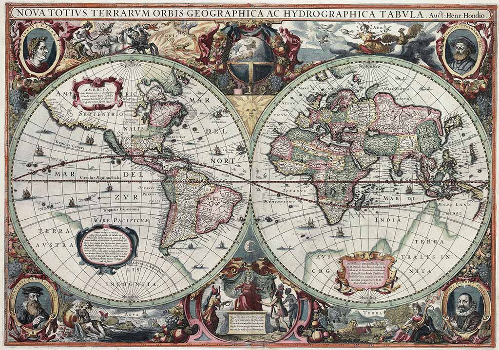
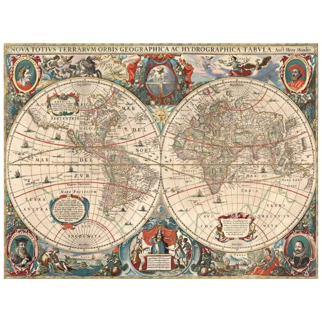
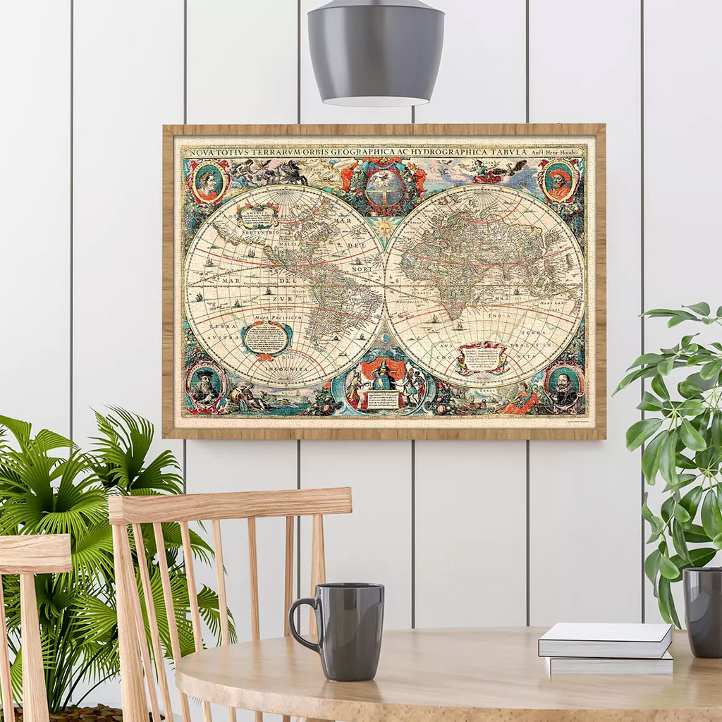
Discover the art style of world map puzzles with Henry Hondius ‘s magnificent 1641 map.
Puzzle Art thanks to these editions is pleased to offer you this art puzzle that pays homage to the great artist who, with Mercator, drew an accurate global map: the NOVA TOTIUS TERRARUM ORBIS TABULA.
Questo puzzle è momentaneamente esaurito.
Nel frattempo, ti suggeriamo alcuni puzzle d’arte che potrebbero piacerti!
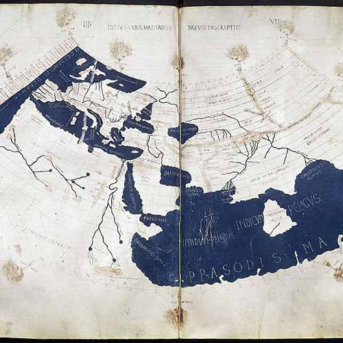
Henry Hondius’s Puzzle World Map is one of the most famous and richly detailed world maps of the seventeenth century.
With this wonderful art puzzle, you can discover the beauty of historical maps and artwork. This puzzle is suitable for both experienced puzzlers and beginners, thanks to its rich detail.
Henry Hondius first published his map in the 1630 edition of the Mercator-Hondius Atlas. It includes unique geographical features and lush details.
At the bottom right is written the date 1630, marking it as the first state of the map.
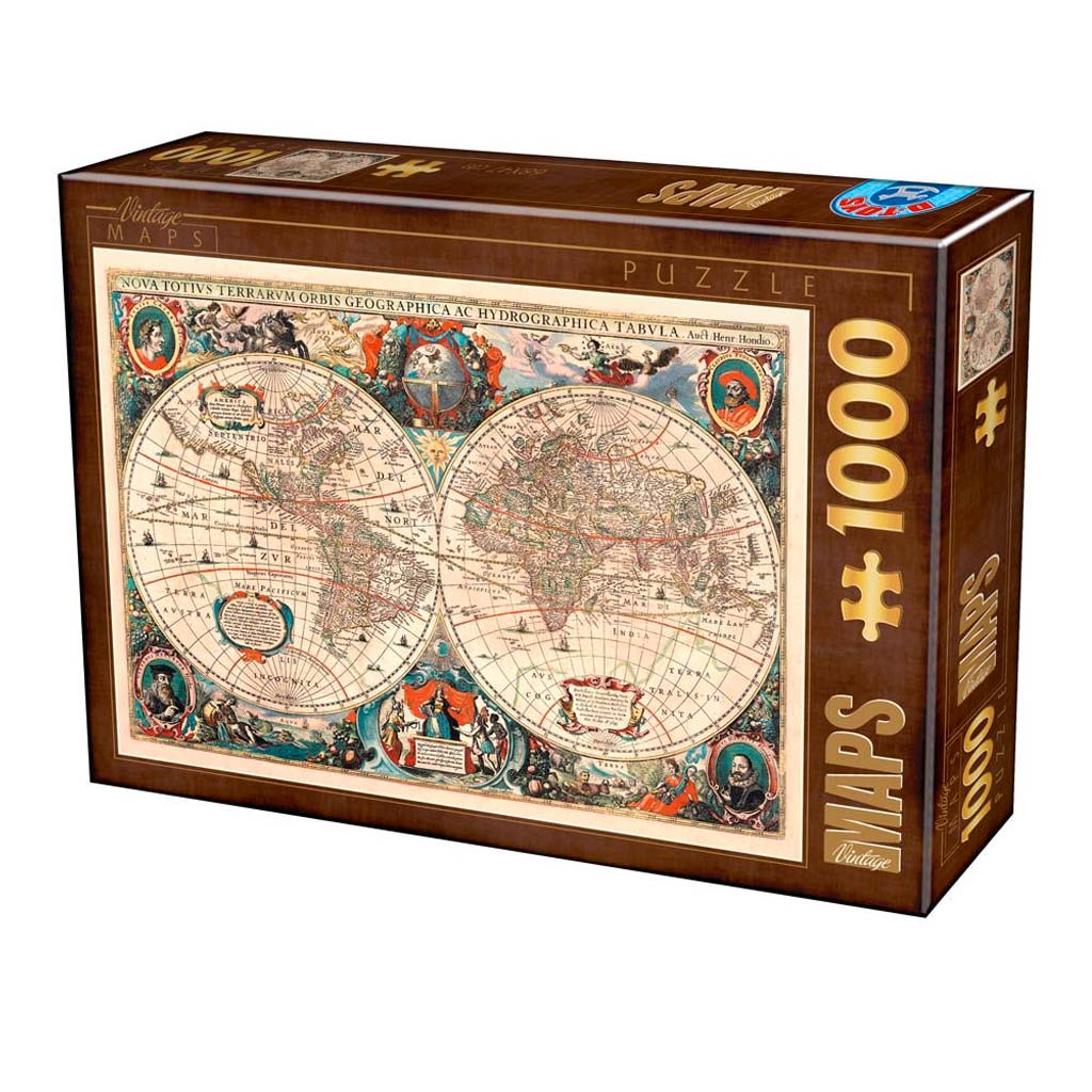
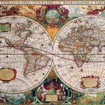
The 1000-piece Henry Hodius puzzle from D-Toys is a stunning example of an art puzzle and World Map puzzle.
The puzzle in question depicts one of the most famous and richly detailed world maps in the entire history of ancient atlases.
With this wonderful 1000-piece art puzzle from D-Toys, you can discover all the beauty of history’s maps and artwork.
In fact the NOVA TOTIUS TERRARUM ORBIS TABULA Mercator-Hondius was published for the first time by the cartographer’s father, Joducus Hondius.
This puzzle is perfect for builders new to puzzles because of its colorfulness and rich detail. The puzzle’s colors are very bright and the details are extremely accurate and refined. The puzzle pieces are sturdy and fit together perfectly.
 | Number of pieces 1000 |  | Brand D-Toys |
 | Puzzle dimensions (cm) 47 x 68 |  | Box dimensions (cm) 38 x 26.5 x 5.5 |
Well finished box
Wonderful gift idea
masterpiece of art
Passion for collectors
1000 pieces
Standard grid
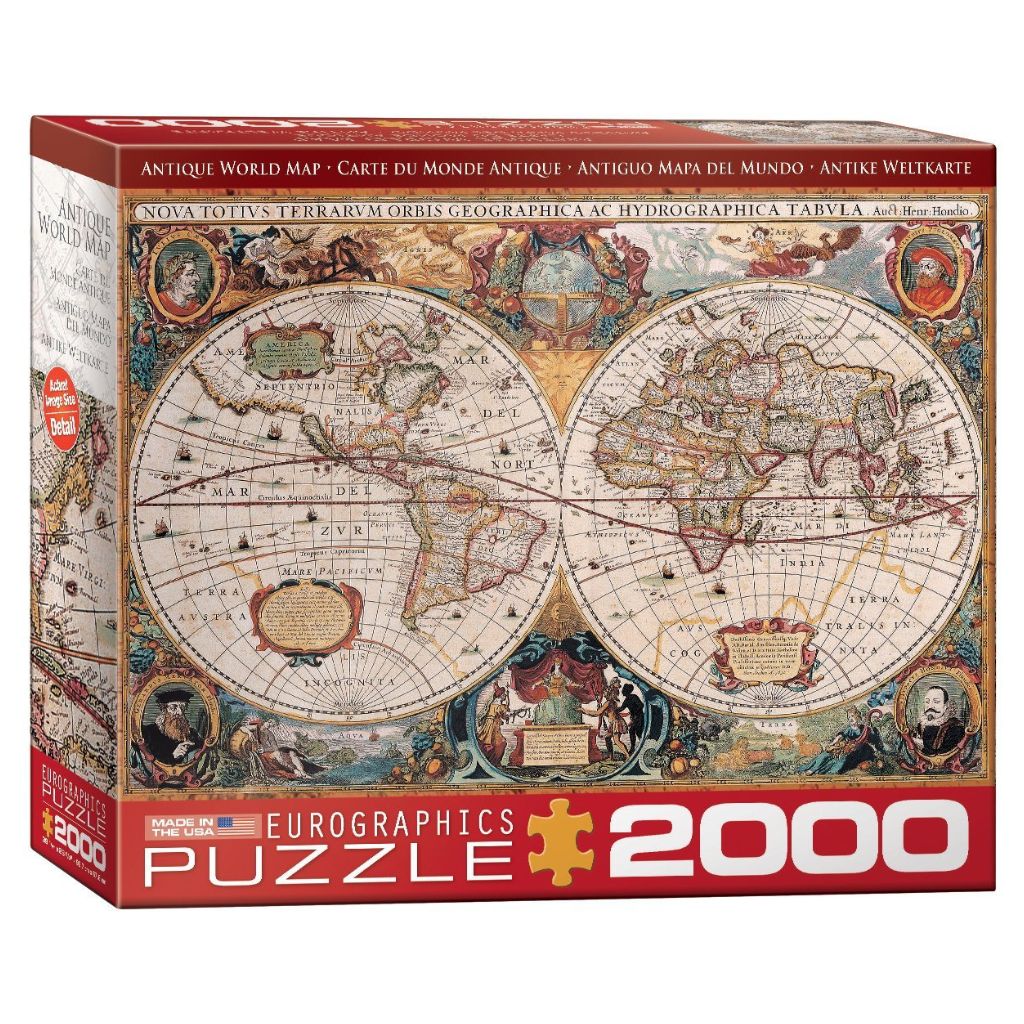
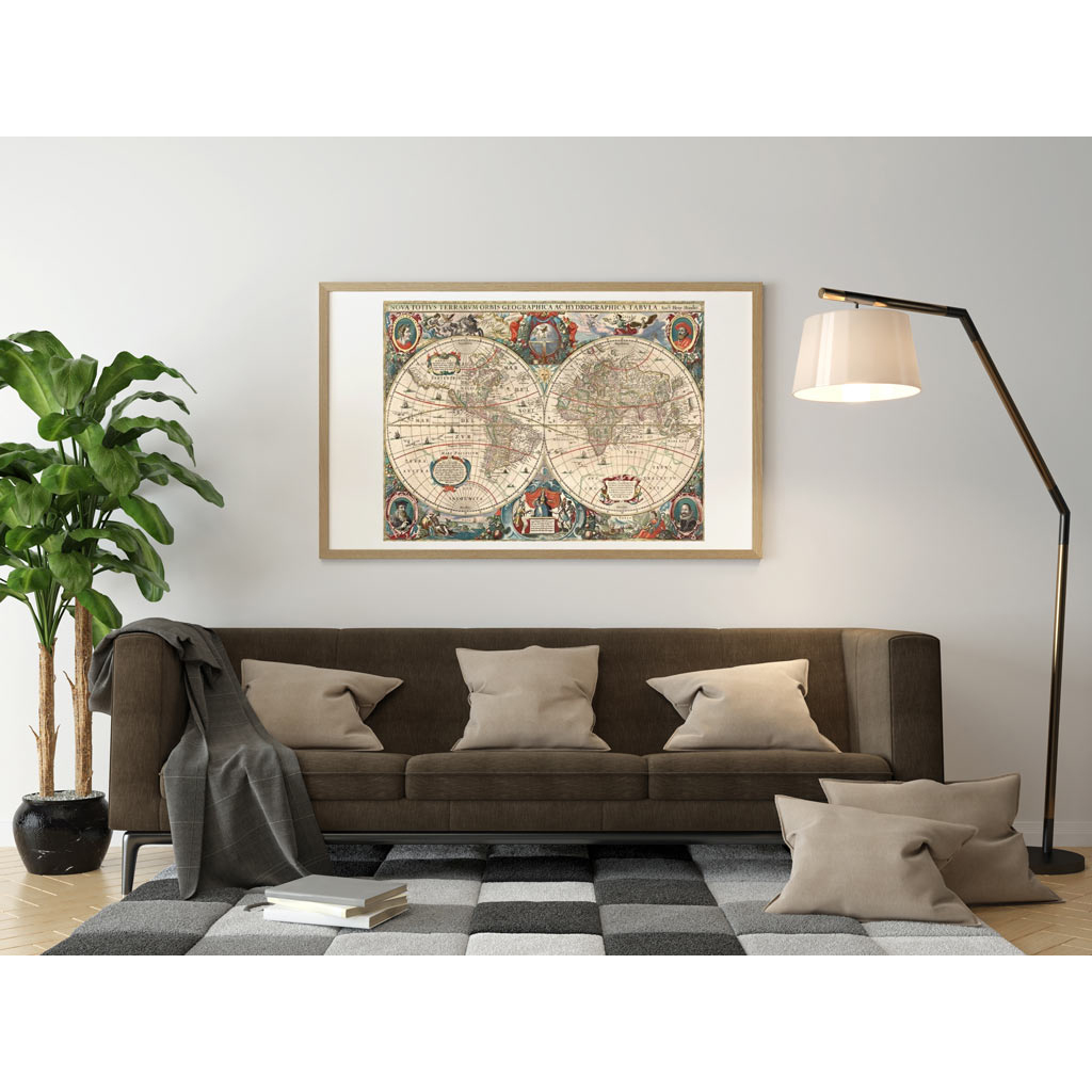
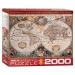
The 2000-piece Eurographics puzzle is a magnificent example of an art puzzle and world map puzzle. This masterpiece depicts one of the most iconic and detailed ancient maps in the history of cartography: the Nova Totius Terrarum Orbis Tabula drawn by Mercator-Hondius.
With this world map puzzle , you can immerse yourself in the beauty of historical maps and discover the treasures of ancient art and geography. The map was first published by cartographer Joducus Hondius, father of Henricus Hondius, and represents a milestone in the history of atlases.
The World Map puzzle is perfect for map enthusiasts and those who enjoy a challenge: the rich detail, vibrant colors, and finely engraved lines offer an engaging and rewarding building experience. The pieces are sturdy, fit together precisely, and the overall quality of the Eurographics product is excellent. A puzzle that combines art, history, and fun, ideal for lovers of maps and global artwork.
| Number of pieces 2000 | | Brand Eurographics |
| Puzzle dimensions (cm) 97 x 66 | | Box dimensions (cm) 38 x 26 x 7 |
Well finished box
Wonderful gift idea
masterpiece of art
Passion for collectors
2000 pieces
Standard grid
Henry Hondius ‘s Puzzle World Map is one of the most famous and richly detailed world maps of the seventeenth century.
Henricus Hondius first published his map in the 1630 edition of the Mercator-Hondius Atlas. It includes unique geographical features and lush details.
At the bottom right, the date 1630 is written, marking it as the first state on the map. Four states on this map were noted between 1630 and 1666. Due to its popularity, the map served as a basis for other cartographers.
Indeed, Hondius’ examples remain some of the most detailed and precise.
The map is embellished with whimsical illustrations, making it an excellent example of Dutch cartography in the Baroque style.
Indeed the map is bordered by mythical scenes and fantastic animals , the world map includes fascinating illustrations of sailing ships and fish, sea monsters and dragons.
The cartographer Henricus Hondius was the son of the famous cartographer Joducus Hondius, whose portrait appears at the bottom left.
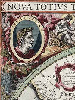
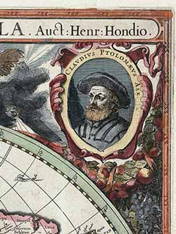
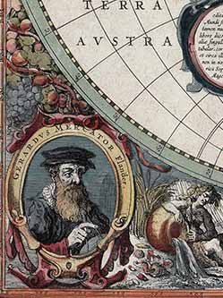
The map also includes portraits of Gerardus Mercator, Claudius Ptolemy, and Julius Caesar.
These portraits are not only eye-catching and historically relevant, but they also serve to establish Netherlandish cartography, exemplified by Hondius and Mercator, alongside the Roman cartographic tradition.
In addition to the many beautiful illustrations and details of the map, several geographic features included in this map are notable, including California as an island, the river networks and lakes of North America, and the coastline of Australia.
Today, maps are primarily considered location and navigation tools. Whether paper maps or, more often, digital ones, they provide information about nearby locations or guide us from one place to another with maximum speed and efficiency.
Throughout history, however, maps have been used for many purposes. In fact, ever since humanity began carving graffiti on rocks 40,000 years ago , it was more a symbol of its existence than a means of orientation.
Examining our surroundings spatially is a fundamental human activity, which psychologists call ” cognitive mapping .” While other animals mark their territories, we are the only species capable of mapping our surroundings.
The term map was first used in English in the 16th century. The definition of map is broad and includes all the different cultural traditions and their cartographic criteria: from the Greek pinax to the Latin mappa , to the Chinese tu and the Arabic şūrah.
Claudius Ptolemy was the first classical scholar to apply geometry and mathematics to the study of the Earth. He wrote a treatise entitled Geographia around 150 AD, in which he developed a scientific method for projecting the globe onto a sheet of paper (or, in Ptolemy’s case, papyrus).
The treatise defined the study of geography, explained how to draw regional and world maps using basic principles of geometry and mathematics to create two master projections, and listed 8,000 places in the classical world.
Ptolemy’s projection remained fundamental for geographers and cartographers for millennia to follow.
In fact, Ptolemy introduced a basic grid (coordinate grid) using latitude and longitude derived from centuries of Greek, Persian, Roman, and Arabic data, and on this basis he scaled the inhabited world, which he called the ecumene.
Ptolemy’s picture of the world extended from the Canary Islands in the west to modern Korea in the east .
The northernmost point was Thule, identified by some as some part of Scandinavia or the Orkney Islands, while the southernmost was the Sahara.
African, joined to Southeast Asia.
Ptolemy’s geography did not include the Americas or the Pacific Ocean, the width of the Mediterranean Sea was overestimated, and the circumference of the Earth was underestimated.
The earliest surviving editions of the Geographia, from the late 13th century, are Byzantine. For this reason, scholars wonder whether Ptolemy himself drew a map.
The Mercator-Hondius atlas was first published by the cartographer’s father, Joducus Hondius.
Joducus Hondius obtained engravings of Mercator’s map from Mercator’s relatives and republished them, along with his own work. The atlas was incredibly successful commercially, and its world map remained unchanged from Mercator’s depiction until the creation of this map by Henricus Hondius and his partner Jan Jansson.
Henricus Hondius’s World Map puzzle is as historically significant as it is aesthetically pleasing. It’s packed with unique geographical details and whimsical illustrations.
Indeed, this map will certainly be of interest to any collector of noteworthy world maps.
Traced in fainter lines at the bottom of the map appears the mythically massive “ Unknown Southern Land ,” as was popular in maps of this time period.
The place name Beach is included in the upper part of Terra Australis , a common misplace of an area later believed to be in Indochina or the Malay Peninsula.
The toponym originated from the writings of Marco Polo.
Evidence of Dutch exploration south of New Guinea towards Australia is clear with the inclusion of multiple coastal place names, including the name “K eerweer “ , drawn on this map as part of New Guinea.
The Dutch navigator Willem Jansz (Janszoon), aboard his ship Duyfken , became in 1606 the first (documented) European to make contact with Australia.
Jansz failed to see the Torres Strait separating New Guinea and Australia, so he mistook the Australian coast as a continuation of New Guinea.
Jansz charted the western side of what would become known as Cape York and the Gulf of Carpentaria , making landfall a couple of times and skirmishing with the indigenous population.
Keerweer , Dutch for “go back,” was named after the site that Willem Jansz decided to return to Java with what remained of his crew after a particularly deadly encounter with Aboriginal people.
The inclusion of the Australian coast on this map traces the beginning of Dutch knowledge of the Australian continent, preserving a time when “ The Unknown Southern Land” was rapidly becoming known.
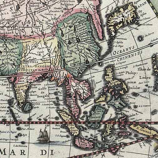
The Dutch presence in Southeast Asia at this time was significant, which is easily visible on this map through its superb detail of the area.
Noteworthy on this map is the excellent initial rendering of the Philippines, as well as the identification of Korea as an isthmus, not an island as previously believed. The sea named “Mare Lant Chidol” is correctly located under Java, although the imprecise spelling of the Malay-Javanese term ” Laut Kidul ” (South Sea) would persist in European cartographic tradition for quite some time.
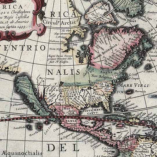
California is shown here as an island, reflecting a widespread belief among Europeans from the 16th to the 18th century. From its first depiction on a printed map by Diego Gutiérrez in 1562, California was shown by cartographers as part of North America.
The creation of California as an island was most likely the result of reading the travelogue of Sebastian Vizcaino, who had been sent north to the California coast in 1602. A Carmelite friar who accompanied him later described the land as an island, a description first published in Juan Torquemada’s Monarquia Indiana (1613) with the details of the island somewhat reduced.
In the 1620s, many cartographers chose to depict the peninsula as an island. This included the author of this map, Henricus Hondius, who published the first atlas map focusing exclusively on North America, with the island prominently featured, in 1636.
In North America, the northeastern section of Canada has been significantly redrawn from previous maps and now includes Baffin Island, referred to on this map as “Queen Anne’s forland.”
An early conception of the Mississippi River and the Great Lakes is present on the North American continent. Virginia and Florida are prominently named, and to the north, the newly discovered regions reached by Henry Hudson are identified with his name.
A large western landmass identified as Nova Albion (popularized by the accounts of Sir Francis Drake) is shown, with Cape Mendocino extending to within a few hundred miles of Japan.
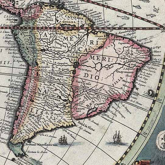
In South America , the Le Maire Strait now appears east of the Strait of Magellan. The Le Maire Strait had been discovered only fifteen years before the first version of this map was published, when Jacob Le Maire and Willem Schouten led a circumnavigation to undermine the Dutch East India Company’s trade monopoly.
Complimenti!
hai una vera passione per l'arte!
Visto che sei arrivato fino a qui, meriti un premio!
Ecco uno sconto del 10% per il tuo prossimo capolavoro! ✨
29,90€ Original price was: 29,90€.27,00€Current price is: 27,00€.
29,90€ Original price was: 29,90€.27,50€Current price is: 27,50€.

_balanced.jpg)
Reviews
There are no reviews yet.